
The recent news show that natural disasters continue to surprise us. Scientists and forecasters often see these occurrences coming, but not as early or in as much detail as they would want to deliver obvious, precise warnings.
Scientists require environmental observations from multiple sources to understand, monitor, and anticipate natural hazards, their consequences on humans, and how they will evolve in the changing climate. Data must be gathered, accessible, timely, and reliable.
Because of their global coverage, satellite-observed maps, graphs, models, and other data outputs are crucial [National Academies of Sciences, Engineering, and Medicine, 2018].

A more open data-sharing infrastructure will attract more contributors
Satellite data products help us study natural hazards and support other Earth science activities, such as basic research, artificial intelligence and machine learning applications, education and outreach, and decision-making by community and government leaders, resource and hazard managers, and others.
These strong products are tested and enhanced utilizing global environmental data from the land, air, and sea. Maximizing global scientific community observations is crucial to improving satellite data products and their benefits for Earth research and society.
For model development and applications, the EU’s digital twin of Earth will combine all global observations. Integration across institutional boundaries can be extended to different Earth scientific fields.
Despite efforts by the World Meteorological Organization, the Committee on Earth Observation Satellites (CEOS), and the Open Geospatial Consortium (OGC) to maximize satellite observations, integrating and sharing data from disparate global sources remains difficult [Hills et al., 2022].
A new data infrastructure for acquiring and distributing data that fits the requirements below might overcome these difficulties.
Satellite-In Situ Interaction
Since the 1960s, scientists have used in situ observations from organizations worldwide to generate and enhance satellite data products for study and operations. Weather stations and radar networks verify satellite temperature, precipitation, and soil moisture information.
However, gathering and reporting global in situ observations, especially in remote land and marine locations, is difficult and expensive.
Satellite-based products cover gaps in in situ data and improve global Earth system understanding [National Academies of Sciences, Engineering, and Medicine, 2018]. Even with satellite and in situ data, data gaps remain.
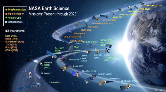
Scientists employ in situ and satellite data to produce products [Kidd et al., 2021]. NASA’s IMERG product package uses observations from dozens of domestic and foreign satellites (Figure 1) [Huffman et al., 2019].
The Tropical Rainfall Measuring Mission and the Global Precipitation Measurement mission, which provide core calibration and evaluation data for IMERG [Huffman et al., 2019], use infrared, passive microwave, and radar sensors to support global precipitation estimates.
IMERG products employ ground-based rain gauges to address satellite data biases that might over- or underestimate precipitation. The Global Precipitation Climatology Centre (GPCC) records precipitation from over 6,000 gauge stations worldwide.